


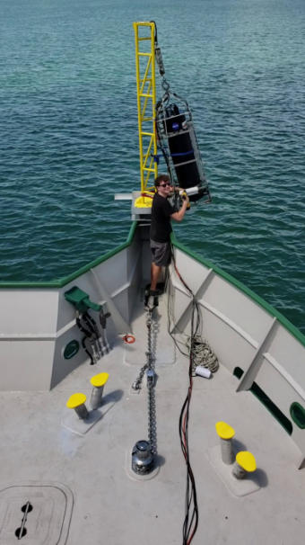
Brian Collister, OEAS Ph.D. student, checks the installation of the LiDAR system mounted to the bow of the R/V Walton Smith at the beginning of a research expedition to the Great Bahama Bank.
By Tiffany Whitfield
Multidisciplinary researchers from Old Dominion University and Bigelow Laboratory for Ocean Sciences have developed a new device to peer further into the ocean's depths.
This new instrument uses Light Detection and Ranging (LiDAR) to detect algae and other particles suspended in the ocean.
A U.S. National Science Foundation and National Aeronautics and Space Administration-funded paper published in Applied Optics reports using the laser-based LiDAR tool to measure the depth distribution of phytoplankton and particles suspended in the ocean deeper than satellites can measure.
"LiDAR has the potential to fill some important gaps in our ability to measure the distribution of biology in the upper ocean, allowing us to better understand the role of ocean ecosystems in Earth's climate," said Brian Collister, a Ph.D. student in the College of Sciences' Department of Ocean, Earth and Atmospheric Sciences.
Collister, the lead study author, used a shipboard LiDAR system.
LiDAR uses light emitted by lasers to gain information about particles in seawater. By sending out pulses of light and timing how long it takes the beams to hit something and bounce back, LiDAR senses reflective particles, like algae and measures their distance, or depth, from the ocean surface.
"Until recently, however, cost and logistics have limited ocean scientists' access to LiDAR systems, and that has slowed the progress of science in this area," said Richard Zimmerman, a study author and Collister's Ph.D. supervisor."This is a significant advance, and it couldrevolutionize our ability to characterize and model marine ecosystems."
"Recent advances in laser technology and high-speed electronics have enabled us to design and construct a compact and rugged LiDAR system with the potential for commercialization that will provide an array of new scientific studies and expand opportunities for environmental monitoring," added Charles Sukenik, one of the study co-authors and chair of ODU's Physics Department.
In 2018, the research teams from ODU and Bigelow Laboratory used LiDAR in the Gulf of Maine to gather information about a bloom of coccolithophores. These algae surround themselves with calcium carbonate plates, which are white and highly reflective. The plates scatter light in a unique way, fundamentally changing how the light waves are oriented - and creating an identifiable signature that the LiDAR system can recognize.
"Traditional satellite remote sensing approaches can collect a wide range of information about the upper ocean, but satellites typically can't 'see' deeper than the top 5 or 10 meters of the sea, and they don't tell you how deep the particles are," said Barney Balch, a senior research scientist at Bigelow Laboratory and an author of the paper. "Harnessing a tool that lets us look so much deeper into the ocean to tell us where the particles are, and what they are made of, is like having a new set of eyes."
Balch's research team has studied the Gulf of Maine for more than two decades through the Gulf of Maine North Atlantic Time Series. Their experience in finding and identifying algae in this ecosystem provided important background information for testing the LiDAR system in what turned out to be the largest coccolithophore bloom observed in the region in 30 years.
"This cruise allowed us an ideal opportunity to try the LiDAR system out with the ability to sample the water and know exactly what species were in it," Balch said. "LiDAR has been used in the ocean for decades, but few, if any, studies have been done inside a confirmed coccolithophore bloom, which profoundly changes how light behaves in the environment."
Coccolithophores are abundant throughout the global ocean and exert a huge level of control on the biogeochemical cycles that shape the planet. Studying them is critical to understanding ocean dynamics, but field research is always costly. The team established that using a relatively inexpensive LiDAR could potentially allow researchers to remotely estimate coccolithophore populations without stopping the ship to collect water samples - increasing their ability to gather valuable data while conserving ship-time funds.
The research team also tested this approach in ocean environments that included the clear depths of the Sargasso Sea and the turbid waters off the coast of New York City. They found it to be effective across these diverse environments, able to probe three times deeper than passive satellite remote sensing techniques. Further research may establish approaches that increase the ability for LiDAR measurements to be taken by satellites to explore the ocean depths.
Related News Stories
ODU Researchers Lead Team That Secured Department of Defense Offshore Wind Grant
The award enhances the University’s efforts to be a leader in the development and implementation of offshore wind technology on the Virginia coast. (More)

ODU's Educator Preparation Programs Achieve CAEP Accreditation
ODU is one of 60 providers from 29 states, the District of Columbia and Puerto Rico to receive the accreditation. (More)
Using Math to Predict New COVID-19 Cases
ODU Professor Norou Diawara uses his findings to pinpoint evolving hotspots. (More)