

By Joe Garvey
A flood-mapping project developed by Old Dominion University researchers is being featured on WHRO's "At A Crossroads" series, which explores how coastal Virginia is coping with rising waters caused by climate change.
This is of critical importance in South Hampton Roads. According to WHRO's reporting, sea levels around southeast Virginia have risen about 20 inches over the past century and are expected to go up nearly 7 feet by 2100 - the fastest rate on the Atlantic Coast.
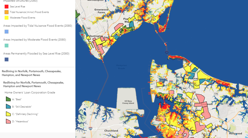
"The web map clearly shows that many of the most socially vulnerable neighborhoods, most of which were historically disadvantaged through redlining and other discriminatory practices, will be substantially impacted by sea level rise and flooding in the future," said George McLeod, director of ODU's Center for Geospatial Science, Education and Analytics (GeoSEA).
The roots of ODU's flood-mapping project can be traced to 2019, when Anne Phillips, special assistant to the governor for coastal adaptation and protection, asked for ODU's assistance in modeling and mapping sea level rise for coastal Virginia. The request came in response to an executive order from Gov. Ralph Northam that required the development of a Coastal Resilience Master Plan. Northam revealed the plan on Dec. 7.
GeoSEA developed data for future time intervals (2040, 2060, 2080) that showed land areas, streets and buildings forecast to be flooded either permanently or frequently by sea level rise and storms, McLeod said.
"We next envisioned how we might leverage and combine these data with other data and information to provide greater value and more insight for the community," McLeod said.
The team worked to identify neighborhoods and communities - particularly those with economically disadvantaged and medically fragile populations - that are often the most acutely impacted by flooding, with an eye toward mitigating risks before events occur.
ODU became involved with the "At A Crossroads" project, which is supported by a grant from the Pulitzer Center on Crisis Reporting, after WHRO reporter Sam Turken came upon GeoSEA's 2020 report, "Future Sea Level and Recurrent Flooding Risk for Coastal Virginia."
"A long phone call with Sam revealed that he had similar ideas about the importance of using our flooding data and maps to illuminate the hazard presented to our most vulnerable community members," McLeod said.
ODU agreed to work with WHRO to develop a web map, and perhaps a future series of web maps, that help educate the Hampton Roads community and support the "At A Crossroads" project, McLeod said.
GeoSEA Center GIS Analyst Chris Davis created the map that was embedded in the project website.
"His map combines all of the aforementioned sea level rise and flood modeling data with data layers from the Centers for Disease Control and Prevention that show the locations of the most socially vulnerable populations in Hampton Roads," McLeod said. "He also combined historical redlining data from University of Richmond Digital Scholarship Lab that reveal neighborhoods that were long the subject of discriminatory and disadvantageous lending practices.
"The combination and map visualization of these data helps to pinpoint those communities that might suffer most from the hazards posed by recurrent and incessant flooding."
McLeod said ODU's Institute for Coastal Adaptation and Resilience (ICAR) plays an integral role in supporting GeoSEA's work and flooding resilience research. Members of ICAR's leadership team, including Tom Allen, Joshua Behr, Carol Considine and Wie Yusef, provide ongoing ideation and project grant funding, he added.
Going forward, McLeod said he has discussed with WHRO the possibly of expanding the web map and research to all of coastal Virginia and possibly other vulnerable areas throughout the country.
"We strongly encourage the use of these data and maps to identify areas of elevated risk and to inform the prioritization of high-resolution and ultra-localized flooding research and mitigation efforts," he said. "Additional localized impacts analysis, at the neighborhood scale, should include comprehensive community population studies and specific asset inventories which are both necessary for identifying and quantifying flood-related risks and the potential cost of response."
Related News Stories

ODU Among the Top 10% Nationally and No. 1 in Virginia in CollegeNET’s Eighth Annual Social Mobility Index Rankings
The University was listed among “noteworthy schools gaining ground in their social mobility efforts despite the lingering COVID-19 pandemic.” (More)
ODU, HRMC Announce Maritime Innovation Initiatives
The ODU Maritime Initiative will coordinate and grow the University’s maritime-related programs, while exploring innovation pathways identified in a new report. (More)
MIBE Partners with Operation Next to Train Military and Spouses for Manufacturing Jobs
The advanced manufacturing certification program blends hands-on and virtual learning to provide the opportunity to earn credentials for in-demand jobs. (More)